Thursday, July 30, 2009

30,000 Islands

The area north of Penetang Harbor along the Eastern Shore of Georgian Bay is known as the 30,000 Islands. Some people say it’s closer to 50 or 60,000; we just know there are a lot! As we headed into the islands we were surprised to see how many homes were perched on any good sized rock. Here’s a couple; on the second one you can see how the trees are windswept by the prevailing westerly winds.


We’ve had rain at least some part of every day except one in the past six or seven days. This was a late afternoon at anchor when it was sunny AND rainy at the same time.


These are the four places we anchored after leaving Midland on Saturday: “Hockey Stick” off Bone Island; Indian Harbor; Wahneen Bay and Kilcousie Bay at Killbear Provincial Park. There were from 5 to 13 other boats in every anchorage. You’re unable to explore the shore on the privately owned land and much more of it is populated by cottages than we would have expected. The Provincial Parks equate to our State Parks and you can go to shore there.

Here’s one of the narrow channels we encountered. Both of us were paying close attention to the charts – both electronic and paper.


This is how close to shore you were supposed to be to get into the Waheene Bay anchorage – yikes!


The scenery inside was beautiful and worth the effort.


A “must see” stop on the Eastern Shore is “Henry’s Fish and Chips” on Frying Pan Island. Here’s Paul talking to the owner, also Paul, after a tasty, but expensive, lunch.


Historical Tidbits:
The first non-native explorer to visit this area was Samuel de Champlain in 1615.
Georgian Bay was named in honor of King George IV in 1820.
Georgian Bay is almost as large as Lake Ontario.
In Canada it’s Pickerel; USA it’s walleye and Europeans call it Pike Perch (same fish)

That's all for now from scenic Parry Sound, about half-way up the Eastern Shore. A lot of sea planes leave from here for tours - they are really loud. We got to provision up here; Sobey's Grocery sends a free shuttle to the marina for pick-ups so that was wonderful. It's still very cool - I'm sitting here typing at a picnic table outside the marina office in jeans and a jacket. The natives are in shorts and tanktops - this is summer darn it! We'll be out of touch again for a few days. We plan to take more of an outside route and not go through so many islands up to Port Au Baril.

Saturday, July 25, 2009

Penetanguishene


We headed the few minutes over to Penetanguishene on Tuesday. Bay Moorings Marina is sponsoring a 2-day gathering for Loopers to share information and socialize.  About 30 boats are expected (29 power and one sailboat). This is the reason we took the side trip to this part of the Georgian Bay instead of heading directly to the North Channel. All the other boats came through the Trent-Severn Waterway instead of the Erie Canal as we did.

Penetanguishene is considered the “Gateway to the Georgian Bay” and we were told this area is considered the “Carribean of the North” as far as cruising is concerned. It is unbelieveable how many huge marinas there are between Penetang and Midland (just across the peninsula). There are literally thousands of slips and lots of sailboats in them.

The Town of Penetanguishene is a picturesque bilingual community; they still have "French" schools and "English" schools. Its’ colorful history reflects its three founding cultures – Aboriginal, French and British. The largest outdoor historic mural in North America is here along with thirty others throughout the town. Here is one of the HMS Bee from Discovery Harbor:


Bay Moorings Marina did a fantastic job of organizing and hosting the Looper Gathering. We stayed there 3 nights; we would have left sooner but it poured most of the day on Thursday. Probably our favorite thing was getting to know fellow Loopers and sailors, Pat and Lynn, who grew up and still live here. Their sailboat is currently stored on the east coast of Florida awaiting their return in October. They’ll spend their second winter in the Bahamas and then continue on the Loop route. Pat actually built their 39ft. sailboat himself and judging from pictures, he did an amazing job. They were so gracious to us, taking us out for breakfast, running us around by car, giving us tips on the area, letting us use their empty slip and inviting us to the Friday Pub Night at their sailing club.  Pat and Paul are going over charts on the picture below. Thanks again Pat and Lynn – I hope we see you again on the waterways!

Here’s Paul making a selection in “The Beer Store” – that’s really what it’s called! Nothing is on display, you decide what you want by looking at the signs on the wall, place your order and it comes out on the conveyer belt. VERY different for us but interesting.


Our current location is marked by the pink arrow on this partial view of the Georgian Bay. We plan to anchor for a few nights on our way to Parry Sound, the next place to provision.

Wednesday, July 22, 2009

Discovery Harbor

After Owen Sound we spent one night at a marina in Meaford. The weather was still windy and unseasonably cool. How do you know when it’s summer in Canada? No one’s wearing a parka! Meaford has a very well cared for marina. I was so impressed with the lovely flowers and landscaping. Lydia, the harbormaster on duty, was pruning shrubs when we came in, we've never seen that before. Here’s their new office, lounge and showers.


This was another point of interest here, the retired Coast Guard Search and Rescue vessel the Westford. You can see that everything is printed in English and French.

We’re now using Skype to call back to the States as it would be $1.25/min. to use our cell phones. Another new experience was ordering potato salad and sliced turkey from a deli in grams.

On Sunday, July 19th, we motor-sailed on rolling seas all the way to Penetang Harbor in southern Georgian Bay. We spent two nights at a great anchorage. We were directly off Discovery Harbor, a reconstructed British naval/army establishment.

On Monday, summer was back, shorts weather again finally. We took a guided tour of the living museum; costumed interpreters help tell the story of life here in the early 1820s when it was home to more than 20 vessels.


Replicas of the H.M.S. Bee, a transport vessel and H.M.S. Tecumseth, built as a warship, are here today. Years ago they took passengers out on the Bay but because of government regulations on safety, etc. they are no longer used in this way. Too bad!

Here’s the lonely Restless Wind at anchor; Magazine Island is to the right. Explosives were stored there to safeguard the settlement. (my first thought was of periodicals – not correct)


We also learned about British Naval Officer Henry Wolsey Bayfield (1795 – 1885). He devoted his life to naval hydrography (charting) and is responsible for charts of the coastal waters of all the Great Lakes including Georgian Bay. He did not chart Lake Michigan as it belonged to the U.S. He did his work here in the winter and was out on the water with his survey crew from the ice melt in spring to autumn. His charts were amazingly accurate considering the tools available at that time: sextant, theodolite, telescope, timekeeper and compass. Nautical surveyors still refer to them today.
There is also a professional summer theatre which performs four shows per season at the King's Wharf Theatre. The large red barn-like building in the upper picture is the venue, it's a replica of the former Naval Storehouse. Here is a link if anyone would like to learn more about this look into the past: http://www.discoveryharbour.on.ca

Friday, July 17, 2009

Bruce Peninsula

A couple more tidbits on Port Elgin: I saw in some travelers' info that from Buffalo, NY to Port Elgin, Ontario would be a 3 ¼ hour trip by car. So it took us 27 days, we had more of an adventure! The sunset viewing from this marina is amazing and a popular thing to do. Sunset was around 9:00 pm eastern time but for about a full hour after, there’s a beautiful orange/red glow on the horizon, as there’s nothing but water between here and the eastern shore of Michigan.

On this map I think you can see Lake Erie at the bottom, then the Detroit River leading into Lake Saint Clair, the St. Clair River leading into Lake Huron and the towns we’ve been to on the eastern shore. Then up at the tip of the Bruce Peninsula is our destination, Tobermory.


Tuesday was a much better day to travel so we left Port Elgin at 6:15am – early for us. It was in the mid-50s with northerly winds so we were quite bundled up for July, especially Ginger!

We had to motor-sail most of the way as our destination was too close to the direction of the wind to sail alone (no, that never happens!) It was 63 nautical miles or 72 statute miles to Tobermory at the tip of the Bruce Peninsula, the strip of land that separates Lake Huron from Georgian Bay (see above map). The Door County Peninsula in Wisconsin is actually Lake Michigan’s counterpart of the Bruce Peninsula. They were both formed from the same Niagara Escarpment. There are two natural harbors near Tobermory: Little Tub and Big Tub. This light marks Big Tub Harbor.

Tobermory means “Well of the Virgin Mary” in Gaelic, tobar moirĂ©. The town of 1,200 residents is known as the diving capital of Canada. Some seasons, 8,000 divers may travel here to explore the many shipwrecks and dive sites that range from 20 ft. to 230 ft. Some of the charter dive boats are converted commercial fishing boats. Glass-bottomed boats like this one leave from here to travel to Fathom Five National Marine Park. This is the area where we planned to anchor but found it’s now restricted. Also the 325 ft. car ferry, Chi-Cheemaun (meaning big canoe) travels between here and Manitoulin Island.

We got a slip at the Tobermory Marina in Little Tub Harbor where we took on 66.3 liters of diesel at $1.20/liter (1 gal. is 3.8 liters). Fish and chips is big here so we had whitefish at The Shipwreck where we could eat outside. On the bill there are 3 separate taxes listed: GST (goods and services tax), Food Tax and Liquor Tax. I guess that’s how they pay for their “free” healthcare. I thought these flowers at a gift shop were so pretty and different that I had to include them.


The next day we had a brisk sail the 18 nautical miles to Winfield Basin. This is the only chance we had to anchor out since Erie, PA. We averaged about 7 knots with sails reefed. There were six other boats here for the night. One sailboat from Canada had the Looper burgee too; they plan to start the Loop in September of 2010. Paul suggested he have the mast shipped and he said they were planning on it. The wind really piped up during the night but it was well protected from all directions as you can see on this picture of the narrow opening to the basin.

We had another day of sailing on Thursday. First the wind was at our back then across our beam. It was a pleasant 23-mile ride to McGregor Harbor off Melville Sound, near Lion Head, Ontario. The bluffs we saw along the way reminded us of the Hudson River Valley north of NYC.
We had the whole anchorage to ourselves, except for cottages along the shore. We were entertained by watching a loon dive for his dinner (we found out they can stay submerged 45 seconds) and listening to the Brewers on satellite radio. No wifi or tv reception here.

Friday morning we sailed and motor-sailed to a marina in Owen Sound, further south in Georgian Bay, and that's where we are right now. Nothing eventful about the trip here, which is not necessarily a bad thing.

Sunday, July 12, 2009

O Canada!

On Thursday, July 9th, we left Port Huron after getting a pump out and fueling up. This is a picture of the Blue Water Bridge, just before you enter Lake Huron.


We saw a 4.2 knot current under the bridge. The 6-ft. drop in elevation from Lake Huron to Lake St. Clair causes the rapid current.

The Lake was flat calm so we motored but it was a good chance for Paul to check out a rattle in the engine. To access the engine (50-hp Perkins diesel), we have to remove the 4-step ladder into the cabin. So this is looking straight down from the cockpit.


We traveled about 7 miles off the shore which was to our southeast. Lake Huron is deeper than Erie, our depth sounder often showed over 100 feet. The wind picked up and we able to motor-sail. We arrived at Harbor Lights Marine in Bayfield late afternoon and are now in Ontario, Canada! Paul called the toll-free phone number to check in with Canadian Customs. He had quite a conversation with the officer who mainly wanted to know our reason for being in the country. Some of the questions asked were: what do we have on board re cash, food and liquor, info on any pets, Paul’s date and place of birth and if we are both US citizens and Paul’s middle name (not mine?). They already had the info on our vessel through cooperation with US Customs. Now that we were “legal”, we raised our Canadian courtesy flag. It goes above the Power Squadron ensign and the AGLCA ensign (that’s the Looper association).
We got a take-out from “The Docks” right at the marina but didn’t see any of Bayfield; it’s about a mile from the marina. There’s a lot of construction still going on to repair the damage a major ice jam did to the docks last winter. Harbor Lights has a 1953 fire engine they use as a shuttle to take boaters to town – that might have been fun!

Friday was very still and very buggy out on the Lake. Since we were just motoring, Paul was able to give the boat a bath on the way and get rid of a few thousand of the gnat-like critters. I couldn’t stand the bugs so Ginger and I spent most of the day down below. Paul’s using the wash-down pump and hose he installed in the anchor locker and it works great with all this fresh water. We’re not missing the salt water we lived on last year!
The wind picked up finally, the bugs left and we were able to sail part of the way to the Kincardine Marina. The town of 12,500 is very proud of their Scottish and Irish heritage. I doubt you can see it on this picture, but there’s a “phantom piper” at the top of the Kincardine Lighthouse piping down the sun. (more construction; they’re putting in a new bridge)
The story goes that in October of 1856, a vessel heading to Kincardine was in trouble in stormy weather. A townsman, Donald Sinclair, feared they wouldn’t find the harbor. He fetched his bagpipes and played them into the harbor. He continued to play the pipes at dusk and the tradition continues to this day.

We spent two nights here. There’s a popular beach, Station Beach, right next to the marina with a gardened boardwalk. Each section has a plaque with the name of who designed and tends it. The water is pretty chilly, we just got our feet wet. This view is to the south.


We were glad we were here on a Saturday as we got to experience the Kincardine Scottish Pipe Band parading down Queen Street. The band has been together since 1908 and the Saturday night parades in summer have gone on since 1948. It was a great experiencel but once again, we were glad Ginger doesn't hear very well!
After the band passes by, anyone who cares to joins in and follows them back to Victoria Park where they form a circle and perform a concert. The town is very proud of them and rightfully so!


Here’s some of our Canadian currency. The paper money is really colorful and I got a kick out of the $1 coins being called “Loonies” as there’s a loon on the opposite side of the Queen; the $2 coin at the bottom is called a “Twonie”. So when Paul went into the bank, they gave him loonies and twonies as he needed change for the laundromat – too funny!
The present exchange rate is 13.95%, meaning for $100 in US dollars, you’d get $113.95 in Canadian money. When you use a credit card from the US, your account is automatically charged the exchange rate. We definitely noticed higher prices in the grocery store and at the laundromat, for a quarter you got a whole FIVE minutes of dryer time! I took most of the clothes back to the boat damp and hung them out on the boom and life lines!

Also we’ll need to adjust to metric measurements and Celsius for temperatures. Today someone told me it’s been a really cool summer, that it should be about 30 by now (which to me means 86 degrees). They use the word "hydro" for electric at the marinas and they say “holiday” instead of vacation which I think it kind of cute. Most signs and labels are in English and French.

Leaving Kincardine, we saw many wind generators along the Lake and passed by the Bruce Nuclear Power Development at Douglas Point, one of the world's largest nuclear plants. We arrived at Port Elgin (that's with a hard G) Sunday afternoon. We're tied up to a wall right in front of a little restaurant that's adjacent to a park and beach. We feel a little like goldfish in a bowl as there were lots of people around Sunday night for a concert in the park. Eating ice cream and checking out the transient boats seemed to be the evening's activity. Here's a view looking forward.


Monday 7/14: We had planned to stay just one night but are still here. It was really blowing early this morning when we would have left and we just weren't up for a "lumpy" ride for such a long distance - all the way to Tobermory. We had breakfast at the little restaurant here and took our bikes into town. Paul went into a LCBO which is the Liquor Control Board of Ontario for a box of wine. No beer or liquor is sold in any convenience or grocery stores (now we know we're not in Wisconsin anymore!) Also any alcohol is heavily taxed so the price was about 1/3 more - great.

Wednesday, July 8, 2009

The End of Lake Erie

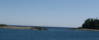
It was a motor sail leaving the Erie Islands heading to Detroit. Two milestones on the way: we saw the last of Lake Erie and turned 2,000 hours on our engine. We were at 1,100 when we began the trip. Paul says that’s why this should have been a motor trip! This is a view heading into the Livingstone Channel, one of a series of bypass channels of the Detroit River. This one was about 5 miles long and 33 miles deep.


We were going against a current of approximately 3 mph so our knot meter speed and SOG (speed over ground) on the GPS were showing quite a disparity. Since it was Sunday on a holiday weekend, there were lots of power boats overtaking us. The wakes they caused added to the chop we were already feeling – rather a rough ride. Here they come!


We passed an area of McMansions along the shoreline then an industrial area, US Steel and Great Lakes Works were a couple of the larger ones. Here’s a view of the Ambassador Bridge and the skyline of Detroit. Windsor, Ontario is directly across from Detroit. Caesar’s seemed to have the most prominent buildings on the Windsor side.


Here’s the Detroit Princess Paddlewheel and the corporate offices of General Motors, which has been in the news quite often lately with all of their financial woes.


We called ahead to Kean’s Marine in Detroit for a slip for the night. I found out they don’t use the word “slip” in these parts, it’s called a WELL. We got to Well #120 about 6:15, after ten hours on the water. We were too late to get a key for the gate as the office closed at 5pm but we hadn’t planned to leave the marina anyway. You would have to get a car service to go anywhere, nothing is within walking distance and that’s not advised.

As we left Kean’s on Monday, we saw groups of junior sailors out for sailing class but were surprised as it was really windy. We saw one boat capsize but there were plenty of monitors keeping an eye on things.

We were able to sail on a beam reach heading northeast on Lake Saint Clair, winds were from the northwest. It’s a very shallow lake, about 14 feet outside the shipping channel. We stayed in the channel as it’s the most direct route to the St. Clair River and is dredged to about 33 feet. We hit 9 knots a few times – what a treat to have the wind in our favor for a change. Here’s me taking a brief turn, it’s usually Cap’n Paul at the wheel but I’d much rather have the helm when we’re not motoring.


It seems as though as soon as we went from Ohio to Michigan, the water turned this pretty blue-green color, we think it’s the sandy bottom that causes it. It reminds me of the Florida Keys. Sometimes I find myself looking for dolphins and wondering where all the pelicans are!


After sailing ALL the way across Lake Saint Clair, we were on the St. Clair River (Saint is only abbreviated for the river for some reason). It was a rather odd feeling going down the center of the river with Michigan on our left and Ontario, Canada on our right. We got a WELL at the Harbor Club in Algonac, MI which was on a channel about a mile off the river. We spied a KFC sign within walking distance and decided to be bad to our arteries and got a carry-out. I don’t think we’d been there in years. There was no wifi or TV reception in Algonac but the showers were pretty nice.

When we left Algonac Tuesday morning, it was in the 50s and the Canadian man in the boat next to us was shirtless! I couldn’t decide if he was just very warm-blooded, showing off his tan or crazy!

We fought the current again all the way up the St. Clair River. You feel you’re making great time when the knot meter shows 6+ knots until you check the GPS and it shows barely 4 knots. We were also motoring directly into the wind which slowed us down even more. We saw our first freighter on Lake Saint Clair but saw more on the river. The river is wide enough that no communication with the freighter captain is necessary, unlike the narrow rivers we were on down south. Here’s one of the big guys.


After 35 nautical miles, we turned onto the Black River into Port Huron, MI in time to make the 5pm bridge opening. We got a well (or maybe they’re slips again here) at the River Street Marina. It’s a nice facility but my favorite thing is probably the few steps to take Ginger to the grass, it’s usually quite a hike. The banners on the street lights remind us we're getting very close to Canada.


We needed to do an errand and stock up on some groceries so the Blue Water Area Transit (bus) seemed the best option as shopping was quite a distance from the river. Long story short: We spent FOUR hours doing those two things! That will certainly make one appreciate having a car at your disposal. The caption for this picture could be "WHERE’S THAT BUS???" By the way, Ginger is sleeping in that canvas bag at the bottom of the picture. She went undiscovered on several bus rides, at Target and the Kroger grocery store. Good Dog!


We plan to leave early tomorrow, destination Bayfield, Ontario, Canada. I hope to keep blogging regularly but we're not sure how often we'll get a good wifi signal when we get WAY up north!

Tuesday, July 7, 2009

Sandusky and Put-in-Bay

We actually had a nice sail to Sandusky. It was only about 10 miles but not having to motor was a novelty to us. We had this view of the amusement park on Cedar Point just as we came into Sandusky Bay. I couldn’t believe the vertical drop on some of the rides.


We got a slip at The Dock of the Bay Marina. Harry the Dockmaster was having a little “Canada Day” party with four Canadian boaters who observed July1st by having cocktails WAY before 5 o’clock. Speaking of Canada, this is where we planned to take care of the paperwork needed to enter our neighbor to the north. First we each needed three photos so off we went to “Snap Shots” to have that done. Then we found the U.S. Customs and Border Protection, gave the officer our photos, passports, one of our driver’s licenses and boat information. We now have our CBP Form I-68 forms in hand; luckily both these places were within walking distance from the marina. Paul had already gone online to get the decal required for boats over 30 feet. Supposedly the fine can be up to $10,000 without it. Needless to say there are many more regulations today compared to the last time we boated in Canadian waters way back in 1982.

The next day was breezy and cloudy but no storms expected so we headed northwest to Put-in-Bay on South Bass Island. There are 11 Erie Islands, but only three are open to the public: Kelleys Island, Middle Bass and South Bass Islands. All the rest are privately owned. We could sail a lot of the way there too but it was really close to the wind. Here’s a peek through the dodger.

For awhile it was pretty rocky so Ginger was more secure in the pet carrier we got for the flight to NY. It was one of the things left in Kyle’s car but he mailed it back to us at my cousin’s in Cleveland so that worked out well. She actually fell asleep in there.


We grabbed a mooring ball, one of about 80 maintained by The Boardwalk Marina and Restaurant in Put-in-Bay, hereafter known as PIB. PIB has been an ideal stopping point for boaters ever since Native Americans “put in at the bay” during their many journeys across Lake Erie. We rocked around quite a bit the first night as winds were causing quite a chop. Water taxi service is included in the daily fee for the mooring ball. Here’s one of the drivers approaching our address (H-6) to drop us off after a shore visit.


In the morning we had coffee and a bite at the Village Bakery and met a boating couple from Rocky River, OH who gave us some tips about the area. We did the tourist thing and took a tour of the island on the little yellow and orange Tour Train, the drivers are always entertaining. We got off to tour the Heineman’s Winery which is the oldest family-owned winery in Ohio, in operation since 1888. We also got to stand in a real geode; a tour of the Crystal Cave is included in the winery tour – such a deal. It was 57 degrees down there; I wouldn’t recommend it for claustrophobics. After a sample glass of wine we walked to the “GOAT Soup and Whiskey” for lunch (funny name but the food was good and we could eat outdoors). Ginger made many friends there with her antics; she gets quite animated when there’s food to be had. Then it was back on the Tour Train to head back to the waterfront.

There used to be 1,000 year-round residents on the island, currently there are 350; 80 of them are students in the K-12 school we passed. The HS Class of 2009 had 5 graduates. There are 5 full-time police officers in the winter and 30 in the summer. There are no doctors on the island, emergency patients are taken by helicopter to the mainland. There are only two churches, one Episcopal and one Roman Catholic but numerous bars. One of them claims to be the “longest bar in the world” but our son in Milwaukee informed us that a Milw bar also claims that distinction. Since it was 4th of July weekend, PIB was hopping. The bar scene is pretty active in the evening but we were back on the boat by nightfall and left that to the “young people”. This is how most of the tourists get around – there are golf carts to rent everywhere:

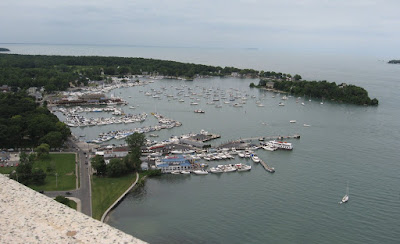
Perry’s Victory and International Peace Memorial was our landmark heading to PIB as it rises 352 feet over Lake Erie. It was built between 1912 and 1915 to commemorate Admiral Perry’s victory over the British fleet in Lake Erie during the War of 1812. This victory helped persuade the British to cease hostilities and enabled the U.S. to claim the Northwest at the peace talks a year later and contributed to a lasting peace between the U.S. and the British.

I wasn’t able to take the elevator up with Ginger, “No Pets Allowed”, but Paul went up to the top and got this great picture. We’re to the far left side of the mooring field, the ferry dock is at the bottom. On clear days you can see 10 miles northwest to the battle site.


We saw a parade of antique cars on the 4th and got a kick out of how fast they rolled by. I said if there HAD been a marching band, they’d have been run over! The fireworks display on Saturday night was fabulous, lasting about 45 minutes. We know Ginger is REALLY deaf as she fell asleep in the midst of the kabooms! She used to panic when a little firecracker went off in the neighborhood. This is a peaceful sunset moments before the action started.


We hadn’t really planned to be anywhere special on the 4th as we didn’t want to be somewhere crowded and crazy but we had a great time on our 3 nights in PIB. This was our last night spent in Ohio - on to Michigan.