Wednesday, June 25, 2008

Solomons Island, Oxford, Cambridge, MD

We were in Solomons Island, MD four nights; two at Calvert’s Marina and two at anchor near the Holiday Inn. You can use their dinghy dock for $2/day and we could grab the hotel's wifi signal. If we were ZZ Top fans, a bonus would have been being able to hear the live concert coming from the maritime museum Monday night. We’re not huge fans of the classic rock trio so we were glad we weren’t closer to the action!

The other excitement started out with a search for ice cream. We took the long dinghy ride from our anchorage to the other end of town to the public dock and walked a bit.

As we had cones in hand, the sky darkened and the winds swirled down the street. Instead of taking cover, we ran back to the dinghy as we wanted to make sure our anchor was holding in the storm. Here’s a picture of the wild ride back to the boat.

First we got wet from the wave action, then we got wetter from the pouring rain – at least it washed off the salt water! Our anchor was fine but we did see another sailboat whose anchor must have been sliding as they were heading over to a mooring ball to grab on. The storms do come up fast around here.

Leaving the Solomons there was a lot of radio traffic requesting boaters to stay a mile off a specific target area. It was coming from the nearby Patuxent River Naval Air Warfare Center – a good place to stay clear of! During WW II this area was a very active ATB (Amphibious Training Base). Our days of finding locally harvested shrimp on the menu is past; crab, especially Blue Crab, is king here.

We went through another thunderstorm anchored off Oxford, MD off the Choptank River. I think the rainfall levels must be in good shape by now with three storms in the past five days. We saw the m/v Mystic Bond there with a “For Sale” on it. It belongs to Canadian friends we’d met back in IL in Sept. who have finished the Loop but we were surprised to see the boat for sale. I don’t think that will happen to us but you never know!

We moved on to another of the English Crown Colonies, Cambridge, and enjoyed the free dock there for two nights. It was directly in front of the Dorchester County building and we don’t think they minded sharing their restrooms with us during office hours. This was about the time we realized Ginger had an infestation of fleas! This is something we've never dealt with in our Wisconsin weather so it was all new to us. We weren't able to locate a groomer here or any products that might help so we had to take our fleas along with us! To be continued.....


We had a great lunch at Snapper’s Waterfront CafĂ© with the couple living aboard m/v “Tardis”, the boat ahead of us at the dock. They’re graduate Loopers and were kind enough to help us with our starter problem as we were leaving.

The boat below is an example of the dreaded "brown mustache" I mentioned awhile back. The cypress roots and other vegetation contains tannins which color the water and it can stain your hull. We don't have one as Cap'n Paul is very diligent about keeping a clean ship!

I’ll close with a sign we saw in the Solomons:

Monday, June 16, 2008

Chesapeake Bay and into Maryland

We ended up spending four nights in Hampton, VA; two anchored off the downtown and two at the city docks plugged in to use the air conditioning during the heat wave. We talked to a sailor also at anchor who sailed up from Miami – five days on the ocean and they didn’t even go into the marina to “re-charge”. I was amazed – what troopers.

We were able to meet up with Paul’s brother Jim again. He drove over from Richmond with a mail package Eric forwarded to him. Jim was nice enough to haul us around town to do errands, shopping and laundry – thanks again, Jim!

When the winds switched to the south, it got really hazy and we could smell the smoke from the fire in the Dismal Swamp started from logging equipment. I guess we got through there just in time; I last heard on the news that nearly 1,000 acres had burned. There’s also a wildfire burning further south in N.C. that’s causing the smoky conditions.

After rounding Point Comfort near Hampton, we were on the famed Chesapeake Bay. It was named by John Smith for the Indian tribe of the same name. The shoreline and water reminded us very much of sailing back on Green Bay but this bay is WAY bigger. It has a surface area of 4,300 square miles and 7,000 miles of tidal shoreline including all the many river and creeks flowing into it. Here are a few of the sights:
This could be Green Bay (except for the jellyfish!) The biting flies feel just the same.


We're not used to seeing lighthouses out in the water. This one had an unusual name: "Point No Point Light".


Paul is smiling - we're actually sailing on Chesapeake Bay! It felt like a milestone.

We anchored two nights so far, near Fishing Bay which is off the Piankatank River near Deltaville and at Sandy Point off the Great Wicomico River near Reedville. Both were great anchorages, except for the odor at Reedville. Menhaden fish are processed there and made into fishmeal which is used in poultry and livestock feeds, oils used in various products and as an ingredient in margerine in Europe. There are planes that spot the schools of Menhaden and direct the fishing boats to them. Here’s the sunset at Fishing Bay:


We passed the mouth of the Potomoc River where you would turn off for a long side trip to Washington, D.C. Since we'd visited there numerous times we didn't make the trip but I'm sure it would be amazing to see the city from the water.

We’re currently in the Solomons Island, Maryland area off the Patuxent River. It’s a really neat area with 11 marinas in a relatively small area – boats, boats everywhere – mostly sail. This is our second night at Calvert’s Marina which is $1/ft – best price we’ve seen in a long time. They have a Mercedes for their courtesy car (not that kind of Mercedes). Not sure how old it is but it has over 218,000 miles on it and made a lot of strange noises. It served the purpose and got us to the Food Lion and back. Here's the view across Back Creek from our marina at dusk.

The weather’s been great since the dandy thunderstorm Saturday night. This is us at the floating dock just before the storm. We made it to the little restaurant at the marina and back without getting wet but then it really let loose.

Lastly, HAPPY FATHER’S DAY (belatedly) to all the Dads. And HAPPY BIRTHDAY to our oldest, Eric, who celebrated his birthday on Sunday in New York City. This is 18-mos. old Eric and the 1977 version of the three of us.

Here's a more current Eric with his love, Diana.

Paul did some addition and found that as of June 11, we had traveled 3,710 statute miles on this journey of a lifetime. Thank the Good Lord for safe travel thus far!

Tuesday, June 10, 2008

Harborfest in Norfolk, VA

Coming into Portsmouth and Norfolk we had some waiting getting through two bridges on the Elizabeth River. They’re restricted from 3:30 to 5:30pm due to traffic and we were delayed at a R.R. bridge so there was a lot of sitting and waiting. We got a slip at the Tidewater Yacht Marina on the Portsmouth side and enjoyed modern conveniences once again.

Some tidbits about Portsmouth, VA: it's located on the world's largest and deepest natural harbor and is located at the Zero Mile Marker on the ICW - the midway point between Miami and Maine.

The next day we headed out to the anchorage off Hospital Point, home of the country’s oldest and largest US naval hospital. We hadn’t planned it this way but we’re here for Norfolk’s 23rd annual Harborfest. This ferry crosses the river every 30 min. for $1 so we went over to look around. Historical tidbit: the first ferry service in America was established on the Elizabeth River between Portsmouth and Norfolk in 1636.


Norfolk is known for their mermaid statues; this is one at the waterfront and one of the tall ships in for the festival.

I liked this sculpture – it’s called The Homecoming.

We had ringside seats Friday evening for the Parade of Sail complete with tall ships and a huge Navy ship with sailors lining the decks – really neat to see.


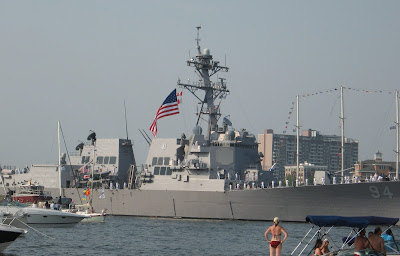
The heat wave continues – really too hot to enjoy the Harborfest. We found some relief in the downtown mall, MacArthur Center, and even discreetly brought our non-service dog in with us. Then we toured the USS Wisconsin battleship and tried to stay in the shade.


Here are some stats of the Iowa -Class ship: Length 887 ft; Beam 108 ft.; Draft with full load 37ft. 9 in. She was launched in December 1943 and saw action in WW II, the Korean War and Operation Desert Storm. The Wisconsin is currently in the Inactive Fleet, reserved for national emergencies. The big guns were pretty impressive.

This was the view of the bow from the dinghy dock – also impressive!


Back at the anchorage it's party time. The boats are pouring in now for the fireworks show tonight; I saw one group of 20 boats rafted together. We counted six “blue lights” cruising around: Portsmouth and Norfolk Police Depts; Portsmouth Fire Dept; Norfolk Fire and Rescue and US Coast Guard. We felt very safe! The Coast Guard did a rescue demonstration complete with helicopter and there was another parade of working boats. The climax was the spectacular fireworks display at 9:30pm. We’re actually glad Ginger is losing her hearing. Fireworks used to terrify her; now she just gets nervous!

Just so you know I’m not exaggerating about the heat, here is proof of the 100+ temps out in the cockpit. It was only 98 down below – pretty tough for these northern people!


Leaving Norfolk it was impressive going past the huge naval ships and aircraft carriers in our "little" boat; there's a major naval presence here. We're currently in Hampton, VA and it's supposedly the last day of the heat wave. It was 100 again today; the average high for early June is 81 degrees. We anchored here the first night and came into the city marina the past two nights mainly to plug in our air conditioning - aaaah, relief!

Monday, June 9, 2008

The Great Dismal Swamp

After Elizabeth City we continued on the scenic Pasquotank River. It started out fairly wide but soon turned into a winding, narrow passage through beautiful wooded areas. We had to be careful of floating deadheads. Next was our first lock since November 10th in Alabama! The South Mills Lock is the southern entrance to the 22-mile Dismal Swamp Canal. It opens four times a day and lifted us up 8 feet as the Swamp is actually higher than the land surrounding it. We decided locking through is MUCH easier with the mast up instead of sticking out at the bow and stern! The Dismal Swamp posed a formidable obstacle to early settlers and explorers. By 1764, the Virginia Assembly granted a company made up of George Washington and five fellow investors, permission to build a canal but only a preliminary ditch was dug.


In 1784, with the backing of Gov. Patrick Henry of Virginia, the Dismal Swamp Canal Company was created and digging began by hired slave labor in 1793. The canal is the oldest one continually operating in the U.S. but is primarily used now for recreational traffic. It was dismally hot and sticky but the scenery was anything but dismal.

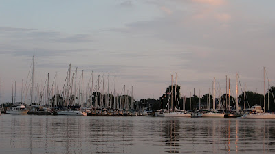
The trees reflect in the water almost like a mirror. Someone wrote that it’s “mysteriously beautiful” and I’d agree.

There were six boats at the free dock the night we were there. The visitors’ center had wonderful A.C. and since it’s a rest stop off a US Highway (17), the restrooms were open 24 hours for the boaters to use. It was rather odd to hear highway traffic when you walked away from the solitude of the canal.

Did I mention it was hot? At 5pm it was 93.7 degrees below in the cabin – a new record; thank goodness for fans! Bad timing for our freezer to die but that’s what happened. Here’s what Ginger thought of it.

The next day we toured the new Education Center. You access it and the nature/biking trails by crossing the canal on a swing bridge. About a month ago there was a lot more boat traffic through here; we’re kind of at the tail end of the snowbirds traveling north.

We left the next morning; it felt great to be moving and creating a breeze! This was the view looking aft; the trail of bubbles was quite visible in the still, dark water.


The canal is about 100 ft. wide and heavily wooded on both sides. We had to stay to the middle to avoid having a tree branch on the banks saying hello to our mast! After a few miles we passed into Virginia.


It was 17 miles to the Deep Creek Lock at the northern end of the canal where we were raised 10 feet up to the Elizabeth River. The mileage sign at the lock showed we’d come 1,239 statute miles from Key West - amazing!

Tuesday, June 3, 2008

Sailing and Motoring On Up the ICW

We had a rather scary moment on our way to Beaufort, NC on Onslow Bay. We knew from radio traffic that there was a very long tow ahead of us trailing dredging pipes. The whole length of it wouldn’t fit in a picture but it was about ¼ mile long!


Paul called the captain and asked if it was okay to pass on the starboard side, he said okay and we proceeded to pass slowly. Unfortunately that part of the channel has some shoaling areas and we were about ¾ of the way past him when we ran aground – really bad timing! We started drifting toward those long pipes and Paul had to radio him to shut his engines down so we wouldn’t get pulled into him. It seemed like forever but eventually we motored off in reverse and just stayed aft of him until there was a safer place to pass. He was going super slowly and we were behind him about an hour. The two tugboats with him had to try and keep the long pipes in place as they were snaking around.

The “other Beaufort” was settled by the French in 1709 and is North Carolina’s third oldest city. We were able to hook onto a mooring ball in Taylors Creek just off the riverfront and dinghy to a free dock. We would never anchor this close to shore but felt okay on a mooring ball; the depth stayed at about 13 feet. (that’s another couple on shore walking their 3 Scotties). We saw two of the wild horses in the area grazing on the shoreline.


We ended up staying two nights on the mooring ball as the weather was changing. We were able to borrow a car from the gent we rented the mooring ball from and got groceries across the bridge in Morehead City. The North Carolina Maritime Museum is here; they have many interesting exhibits along with lovely, clean restrooms! They have artifacts recovered from the 18th century shipwreck believed to be Queen Anne’s Revenge which lies in the waters off Beaufort. She was the flagship of Capt. Edward Teach, otherwise known as Blackbeard the Pirate – aaargh! Here’s one of the lovely restored homes in Beaufort (c. 1886) and one of my favorite flowers, the Easter Lily. Hydrangeas are blooming also in hues I haven’t seen before – just gorgeous.

The next destination is Oriental, NC. This is a sight you don’t like to see along the way. Luckily we managed to miss this shallow spot. Tow Boat U.S. is busy around these parts.


Oriental is located at the mouth of the Neuse River on Pamlico Sound. The Sound reminded us of Lake Winnebago; it’s no more than 20 ft deep and gets choppy in a hurry. The town was once known as Smith’s Creek but was re-named by the postmaster’s wife after she saw the name on the name board of a Union steamship that sank off Hatteras in 1862. I guess she just liked the sound of it! Oriental is called the sailing capital of North Carolina and has three times as many sailboats as residents. This is Oriental Harbor Marina where we stayed for one night. There’s very little tidal action here so no more floating docks.


We were able to sail quite a bit after leaving Oriental; the Neuse and Alligator Rivers are really wide, more like a bay. We also were on the Alligator River/Pungo River Canal (a land cut between the two rivers) heading east for about 20 miles with no chance to sail. It's quite narrow with debris and stumps so you need to keep to the middle. We anchored the next three nights: first in the South River off the Neuse River, next off Bellhaven, then just off the Alligator River where we got to watch (and hear) a North Carolina thunderstorm. It had been close to 90 degrees and humid all day so it cooled things down considerably.

We crossed the Albemarle Sound into the Pasquotank River and saw Coast Guard planes practicing “touch and goes” at the largest and most diverse Coast Guard command in the nation with 1,000 active duty personnel. We’re currently in Elizabeth City, NC - ”One of America’s Best Small Towns”. They have free docks for 14 boats; there are just 5 of us here today. The town is well-known for its’ hospitality to boaters. If enough new boats come in, there’ll be a wine and cheese party and the ladies get a rose; I have my fingers crossed! Nora gave us a ride for groceries and Sam gave Paul a ride to a gas station so I'd agree that it IS a Harbor of Hospitality!


One of us went through the Museum of the Albermarle a block from our dock and enjoyed it and the gift shop very much. A couple of tidbits I picked up: The Coast Guard here is the main air search and rescue base for the Atlantic Coast from New Jersey to Georgia. If we're going to get into trouble this would be the place to do it. The Wright Brothers came to Elizabeth City by car then took a boat to Kitty Hawk. It was there on the Outer Banks where the first aircraft successfully flew in December 1903.