Saturday, May 24, 2008

More Historic South Carolina in Georgetown

North of Charleston, the ICW went through a large area of preserved coastline. The large wetland holdings came from the huge rice plantations which flourished before the Civil War. It’s a major refuge for migrating waterfowl and contains about 20 percent of the coastal marshland on the east coast. The places you could anchor along there weren’t too appealing so we went on to Georgetown where you can anchor just off the public dinghy dock. Georgetown is on the Sampit River which is off the Pee Dee River and Winyah Bay; these names are the most obvious legacies left by the Native Americans who lived here.


Georgetown, named after Prince George who later became George II, was founded in 1730 and is the third oldest city in South Carolina. One of the heroes of the area is Francis Marion, also known as the “Swamp Fox”, who used guerrilla warfare and eluded the British during the Revolutionary War by traveling along swamp paths. The character Benjamin Martin in the movie “The Patriot” is loosely based on Marion’s life. Indigo (dyestuff) and rice were major crops and the seaport exported more rice than any port in the world at one time.

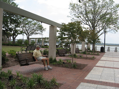
HAPPY MEMORIAL DAY! This is us from the town dock, I loved that it was close enough to row Ginger to shore (also public restrooms for humans were nearby). There was a "Don't Feed the Alligators" sign at the dock. We didn't see any but evidently they're plentiful in the rivers and marshes in the area.

We did our own walking tour of the historic district where more than 50 buildings and sites are listed on the National Register of Historic Places.

The town did a great job with this 1500 foot Harborwalk. A number of restaurants on Front Street have access to it with outdoor seating.

The William Doyle Morgan House (c. 1880). This one was beautifully restored.


This historic home is now a Bed and Breakfast. I thought the porch looked really inviting.


Here's one of the lovely streets lined with Live Oaks. There was a special sign for a 570-year old Champion Live Oak. They're called that because they're green year-round.


This is Prince George, Winyah, Episcopal Church (c. 1747)


Prince George is one of the few original church buildings still in use in South Carolina dating to the colonial period. The box pews were customary in colonial times. The pews were assigned a number and members owned their pew!


Since there was no heat in the church, pew owners frequently brought charcoal burners from their carriages in cold weather and the pews retained the heat. The "good old days"?


Another inviting porch on a lovely old southern home.


The sign below explains the historic building above.


A "watch cat" sleeping on the job inside a store on Front Street.


This town landmark also houses the Rice Museum (c. 1842). It was originally an open-air market. Surrender papers were signed here in 1865.

That's all for Georgetown, we really enjoyed our two nights anchored here. The only downside was the "pungent" odor from the paper/pulp mill when the wind was right. It was very similar to the air when you're nearing Kaukauna on Hwy. 41 in Northeast Wisconsin (many of you will relate!)

Thursday, May 22, 2008

Charleston is Beautiful

Charleston (originally Charles Towne) was founded in 1670 by the British. It was built on a peninsula with the Cooper River and Ashley Rivers flowing around it to form Charleston Harbor. We anchored on the Ashley River just off the Mega Dock of the City Marina for one night and the next day we moved to the Maritime Center on the other side of the peninsula.


Here’s a sunset from the City Marina dinghy dock.


Here’s a view of the city on our way over to the marina. Part of the charm of Charleston is there are no very tall buildings and the church spires are very prominent.

We took a horse-drawn carriage tour which about the only way to see the historic area; no trolleys here. Candace was our driver and this is Richard the Percheron and our carriage. It took old Dick awhile to get in “gear” but he eventually did a fine job for his passengers.


The historic homes are very well cared for and the gardens and flowers are beautiful. The Confederate Jasmine and Magnolia trees were in bloom and smelled wonderful.

Here are a few of the scenes of Charleston:


A replica of the tall ship, La Amistad, was docked at our marina, as a stop on its’ America’s Atlantic Freedom Tour. It was a slave ship made famous by book and movie. There was an area set up at the marina with storyboards and displays for school groups tours.

You would need much more time than we had to see the area. A ferryboat can take you out to tour Fort Sumter in Charleston Harbor. The Fort is famous for being the site of the official start of the Civil War, or, as it’s referred to in the South, “The War of Northern Aggression”. The Citadel, the Military College of South Carolina founded in 1842, is located northwest of Charleston. We stayed an extra night in Charleston as the storm you can see in the above picture was predicted. There was hail and damaging winds in neighboring counties but only rain where we were. The other tall ship there for the Harborfest was "Spirit of South Carolina".

All for now from the Restless Wind currently at anchor off Georgetown, SC.

The Low Country

After leaving Beaufort, we enjoyed one of our all time most calm nights at anchor. We were in Steamboat Creek off the N. Edisto River on the ICW. For once there was zero wind and the nearly full moon shining on the water added to the ambiance. There was a boat landing so I (Em) decided to try out the oars and rowed Ginger to shore. Going over was a snap but returning was a bit of a challenge with the tidal current, it probably took four times as long!

One of the lovely homes on the Beaufort River part of the ICW north of Beaufort.

Low Country View: This boat really isn’t aground. This part of the ICW is just very flat and winding and you see some strange sights.

A view of the Low Country from Steamboat Creek. They call this part of the country the "Coastal Empire" on the local news.


This was the sunset in Steamboat Creek; this sailboat was from St. Louis, MO. You can see smoke coming from a fire on shore that we'd seen all afternoon.

We left mid-morning heading for Charleston.

Friday, May 16, 2008

Savannah, GA and Beaufort, SC

We were in Thunderbolt, GA waiting for our alternator to be repaired until Thursday the 15th. May is starting off to be an expensive month too! Here’s one of the yachts in the boatyard, “Kisses”. I wondered if the owners were some of the Hershey family.

Paul heard one owner’s bill is currently at two million dollars; hard to imagine, isn’t it? Evidently it was in a horrendous storm in the Atlantic and has been in for repairs since last fall. The owners of these yachts are rarely onboard but their crews were certainly busy keeping them squeaky clean just in case they ever showed up.

We did get to spend a day in Savannah, known as the birthplace of Georgia. General James Ogelthorpe founded the colony of Georgia in 1733 when he landed on the Savannah River bluff 18 miles from the Atlantic Ocean. There are over 1,000 historic buildings restored and in use in the 2-square mile historic district. The city was spared being burned as Gen. Sherman had his headquarters here. We took the 90-min. tour on an open-air trolley, shopped a bit, had lunch at The Cotton Exchange at the riverfront and Em finally got her birthday treat (a huge brownie sundae) at Leopold’s, famous for ice cream since 1919. Filming on some famous movies was done here, among them: "Midnight in the Garden of Good and Evil"; "The Legend of Bagger Vance" and "Forrest Gump". Here are a few of the sights:


These green areas are called squares, not parks. The city was laid out on a grid system and there are still 21 of the lovely squares in use. The trees are Live Oaks and what we call spanish moss hanging from them is neither spanish nor moss but air plants.


This is Whitfield Square, named after George Whitefield, an English clergyman who ministered to the city's earliest colonists. The gazebo is a popular spot for weddings.


This is the Cathedral of St. John the Baptist. We toured the inside, the stained glass windows are incredibly beautiful. Another interesting thing about Savannah is it is known as the most haunted city in America as a result of the large number of violent and untimely deaths.

Paula Deen has a restaurant and retail store here called The Lady and Sons. Evidently it's hugely popular and you make your reservations for dinner at 9:30 AM. We went past it on our tour and could see the piles of fried chicken at the buffet table through the windows but thought we'd keep our arteries clear and take a pass!

We traveled the ICW through more of the Low Country, though it didn’t look quite so low and marshy with more trees on shore. We were in the Sea Islands of South Carolina after crossing the Savannah River. We were able to sail quite a bit of the day with southerly winds.


This is a view of Hilton Head Island, South Carolina.

We went past the U.S. Marine Corps Recruit Depot at Parris Island where Marines have been trained since 1915 (no not the same ones). I got a kick out of the 1 800 MARINES on the water tower. After sailing through Port Royal Sound we decided to get a slip at Port Royal Marina, just south of Beaufort, SC. This is the one pronounced BEWFORT, not to be confused with Beaufort, NC pronounced BOWFORT. I think we finally have that straight! We have never bobbed around so much tied up to a dock; the winds were crazy! There were several things to be excited about: free wifi and cable tv AND a courtesy pick-up truck! We haven’t seen that in a very long time. Since it was supposed to storm the next day, we decided to stay two nights. Dockage fees are getting better, $1.50 per foot but now there are charges for pump-outs whereas in Florida it was usually free. We think Florida receives federal funding to help with the costs as part of an environmental program. Whatever the reason, it was much appreciated.

Beaufort is supposed to have all the history and charm of Savannah and Charleston without the traffic. There are a lot of art galleries, shops and eateries in the historic district. A lot of the historic homes along the river are now bed and breakfasts. Here are a few of the sights of Beaufort:
Here's a "swinger" at the riverfront. I thought these swings were a great idea.

We've seen holly bushes before but these had the red berries. It sure doesn't feel like Christmas! Next destination, Charleston, SC.

Monday, May 12, 2008

Georgia On Our Minds

On Wed. the 7th we traveled on the “outside” (the Atlantic Ocean) instead of the ICW, the “inside”. We went through the St. Mary’s Inlet out to the big water and had to go a long way to get past the jettys. We motor-sailed awhile until the winds shifted. We were able to go with sails alone for part of the day at least. We went in at the St. Simon’s Inlet – we had to share the channel with this big guy coming in.


We anchored between two islands – IN GEORGIA! We saw 10 ft. of water when we anchored around 5pm. When we went to bed it was showing 20 ft. The tidal action is still a novelty to us.

The next day we left the anchorage a little before 8am to have the tide in our favor as we were going to be on the inside. We’d heard a lot about this part of the ICW having problems with depth and not being that well marked. We went past Brunswick, GA and were on the Mackay River which led into a series of small rivers and sounds. It was very meandering and marshy. We picked up a swarm of huge greenish flies that only bit occasionally. We’d heard it would start to get buggy around here so we have our bug spray handy (thanks, Sandy!) Around 4:30 we anchored off St. Catherine’s Island in Walberg Creek with two other sailboats. The best thing about this spot was we picked up a really strong wifi signal. The wind really picked up (the second night in a row for that) and with the tidal current keeping us from pointing into the wind it wasn’t that pleasant. Paul was afraid the anchor line might be wound around the keel but thankfully that didn’t happen. Check out the swirling water, definitely not what we’re used to anchoring in back home!


On Friday we left early to get through Hell’s Gate, a notoriously tricky spot, at high water. We passed the mouth of the real Moon River, made famous by the Johnny Mercer song. We saw dolphins, a few shrimp boats and an island populated by wild hogs.


I guess Ginger wasn’t all that thrilled with the scenery.


I don’t think we’ve ever seen a realty sign like this; three private islands could be yours!

We came in to the Thunderbolt Marina in Thunderbolt, GA which is about 6 miles from Savannah on Friday. We’d planned to spend a couple of days seeing Savannah anyway but now we had another reason to stop there. Paul discovered this morning that our alternator went out and this marina has a yard that could do the work. Our refrigeration is giving us problems too we’ll have that checked out as well. This used to be a Palmer-Johnson operation and is now a repair facility for some huge yachts. This is the marina that treats you right. They bring a small box of Krispy-Kreme doughnuts and a morning paper right to your boat – very nice!


Since it was Friday afternoon, the work couldn’t be done until Monday so after one night in the marina we headed to a nearby anchorage, Herb River, for Sat. and Sun. nights and planned to come back to the marina at least once. Saturday night was very calm but Sunday was another story. It was definitely an unusual Birthday/Mother’s Day for Mom as we weren’t even able to get off the boat. There were thunderstorms and high winds; even heard of tornadoes not that far south of us. Going to church and eating out after didn’t happen but Paul promised to take me out today instead. We’ll definitely take a tour of Savannah before we leave the area too.

All for now from the Live Oak Library in Thunderbolt, Georgia.

Wednesday, May 7, 2008

Goodbye to Florida

From St. Augustine we were on the Tolomato River part of the ICW (it’s named after an ancient Indian tribe). We motor-sailed with just the genoa since there were a lot of turns in the river and that was easier to manage. It was refreshing to see a lot of natural areas along the shoreline but as we neared Jacksonville, it was one mansion after another again. At Jacksonville we picked up the St. John’s River which is well known for its’ strong current. You can see the tidal current going past this buoy.

We went past an industrial area with shipbuilding and anchored just off the river between two islands near Broward Bridge. There was a really strong current plus a stiff breeze – one coming from one way and one from the other. It wasn’t the greatest anchorage but not a lot of options here. There was no going to shore for the doggy trip in the morning; when the tide came up the shoreline disappeared!

On Sunday we headed the 4 miles back to the ICW. We opened the Sister’s Creek Bridge and were traveling at 9 knots going through the bridge aided by the current. Sister’s Creek became Saw Pit Creek. They really look more like lakes than what we’d think of as creeks – very wide open. There were lots of egrets and heron and dolphin sightings. We crossed Nassau Sound and were on the S. Amelia River. We traveled 21.3 miles by the time we got to Fernandina Beach which is actually on Amelia Island. The familiar aroma of paper mills was in the air! We hooked up to a mooring ball and had to wait to go ashore as there was a Blessing of the Fleet and boat parade going on. Here are some of the shrimp boats in the parade.

We happened to be here for the last day of the 45th Annual Shrimp Festival. The town was mobbed, a lot like Menominee, MI during the Waterfront Festival. We got some shrimp from food booths manned by local groups, walked through the juried art show and enjoyed live music. It was quite a party, complete with pirates and their ladies!


Evidently the tide in Fernandina Beach is the most dramatic in Florida – a 7 ft. fluctuation, definitely the most tidal effect we’ve seen. The depth at our slip went from 13 feet to 20 feet. If they didn’t have floating docks it’d be pretty ridiculous trying to get on and off your boat.

We got a slip here for Monday night and planned to head out on Tuesday but the winds were supposed to be pretty strong out of the northeast so we decided to wait. So we went back out on a mooring ball on Tuesday. As it turned out I’m glad we stayed because we got to see Jim and Lou again and have lunch together. They were on their drive back “up north” to Richmond, VA after wintering in Bonita Springs, FL. There are a lot of historic buildings here, cute shops and lots of restaurants so it was definitely a worthwhile stop.

It’s time for another sunset. This is looking out at the mooring field from the Fernandina Beach Harbor Marina.
THIS N THAT

We’re seeing a lot of boats from the east coast now, mainly Maryland, Delaware and Rhode Island. They’re heading back home from spending the winter in warmer places.

We noticed we’re starting to hear southern accents again. You just don’t hear that further south in Florida because so many residents are from "up north" and you don't meet many native Floridians.

The State Bird of Florida, the Mockingbird, is very entertaining to listen to. They really put on a show. The first time we heard one we couldn’t believe it was just one bird as they have such a large repertoire of songs!

I checked to see when we first arrived in Florida and it was November 28th. No wonder it felt like we were here a long time – we were. On to Georgia!

Sunday, May 4, 2008

St Augustine

After Daytona Beach, we stayed one night at a marina in Palm Coast, FL. We had planned to anchor out but there were no good options. It was a motor trip; the winds were directly out of the north. We were on the Halifax River part of the ICW until about Ormond by the Sea when it became the Matanzas River. Here is a view of one of the docks at Palm Coast from a nearby bridge. We’re the second boat from the left. The new dinghy just takes up a bit more room on the stern but we like it a lot. The ride is much more stable and much drier.

One our way to St. Augustine, we went past Fort Matanzas, a research reserve with a lot of natural area and Rattlesnake Island. We saw a lot of dolphins along the way. The river became very winding near St. Augustine. Once at St. Augustine, we sat on the south side of The Bridge of Lions for 30 min. waiting for the opening with 5 other sailboats. The goofy bridge tender wouldn’t open because no one officially called him on the radio in time (even though he could see us all sitting there) so he made us wait until 3:30. I guess work has been going on at the bridge since 2005. Here are some of the boats going under the bridge; the lift part of it is temporary. They must have removed the decorative lions during construction as I didn’t see any.

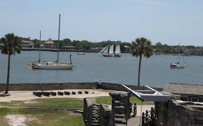
We anchored on the north side of the bridge in Matanzas Bay and spent three nights there. The marina charges $10/day for use of their dinghy dock and facilities. It’s a fairly calm anchorage and convenient to the marina but the best part is the great view. We’re the middle boat in this view of the anchorage. This is the view of Castillo de San Marcos at dusk. The cross you see isn't actually at the fort, it's a bit further north and marks the spot where Pedro Menendez de Aviles actually landed.


There’s so much history here; it was really neat to be so close to this historic site in our very own boat! St. Augustine was established in 1565 by the Spaniards and is the oldest permanent European settlement in the continental United States. The fort, Castillo de San Marcos, was completed in 1695. The fort is surprisingly long lasting; the main reason being the rather rare form of limestone the walls are made of. It's called coquina, spanish for tiny shell. It contains millions of microscopic air pockets making it compressible. When cannonballs hit the fort, they burrowed in, instead of shattering the wall. Rather like if you shot a BB gun into styrofoam.

There’s a great view from up on the gundeck. The schooner under sail is “Freedom” a charter that takes tour groups out several times a day.


These horse-drawn carriages wait on Avenida Menendez for passengers. There were three more parked behind these two. Em’s brother Bob would have loved this. The aroma in the air was reminiscent of Mackinac Island!


We took the Sunshine Bus over to Anastasia Island to tour the St. Augustine Lighthouse and Museum. We actually climbed the 219 steps (equiv. to 14 stories) to the top. My (Em’s) legs were fine going up but felt like rubber by the time we got back down. On the ride back over the bridge we had to wait while it opened for three sailboats. Kind of interesting being on the other end of that process!

Here’s the 165ft. lighthouse and a view from the top looking toward the ocean (that isn’t our anchorage). They did a fantastic job on the restoration of the lighthouse and the museum. If you're interested in more information on the lighthouse, here's their website: http://www.staugustinelighthouse.com/


We’re heading toward Jacksonville later this morning; there isn’t much of Florida left!